


See also Part 2 and Part 3
Natural History of the Finger Lakes, Part 1: Seabed
Ancient in genesis and long evolving, the landscape is a primeval seabed, uplifted, slowly eroded, then dramatically carved and scoured by miles of thick ice sheets.
That in a nutshell is the geologic history of the Finger Lakes region. But it is a sentence that covers eons and glosses over the complex interplay of geologic processes in a globally changing landscape. The timescale is hard to fathom relative to our modern era.
Consider that in geologic time, mountains — the massive and impenetrable barrier between regions and people — are fleeting. They rise up and are literally washed away when perceived over the course of time. In the same way, continents can be visualized as floating across the globe, shifting from tropical to more temperate climes.
Long before the dinosaurs
Of course, it is the shifting of plates that leads to the formation of mountains, and the uplift and erosion of these behemoths is one of the main plot lines in New York’s natural history. The chapter pertinent to the Finger Lakes region dates back hundreds of millions of years to the Devonian Age when the region was part of vast, warm inland sea. This was an age millions of years before the emergence of dinosaurs, when the precursors of life we recognize today were evolving into their first forms: the first insects, the first trees, the first seed-bearing plants, the first ferns, and the first amphibians.
To the east of the Finger Lakes region, mountains as high as the Himalayas were, in their fashion, being created/uplifted. The remnants of these towering behemoths are the modern day Appalachian Mountains which average three thousand feet in elevation — the highest peak today is Mount Mitchell, at 6,684 feet. As a point of comparison, Everest is 29,029 feet and 30 peaks within the Himalayas are over 24,000 feet.
…east of the Finger Lakes region, mountains as high as the Himalayas were being created…
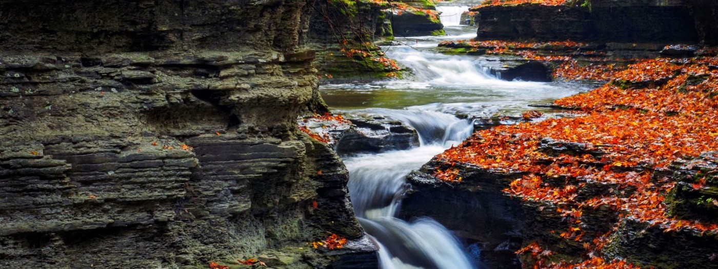
The mountains inevitably eroded and their sediments were deposited in segregated layers. Light silt would deposit further into the seas while heavier particles, such as sand, would deposit closer to shore. Over millions of years, sea levels would fluctuate and shift the heavier deposits of sand atop softer layers. This interweaving of layers is one of the reasons the Finger Lakes has such dazzling waterfalls and gorges, features that took hundreds of millions of years to form.

Any walk in the region within a gorge or beside an exposed rock wall allows you to see and touch these layers. The gorge state parks along the southern tips of the Finger Lakes, such as Watkins Glen, are often cited as the best places to view these layers, but places like Cascadilla Gorge, Grimes Glen, Conklin Gully at High Tor, and Sweedler Preserve at Lick Brook Gorge are equally illustrative.
Often the remains of sea-life would get mixed in with the deposits, mostly calcium-rich shells. These too can be seen in the abundant fossils found along lakeshores, stream beds, or by breaking apart crumbly shale just about anywhere its found along the trails. It is also why Central New Yorkers have “hard” water and see the deleterious effects of acid rain in the lakes and ponds of the Adirondacks. (The basic pH of calcium carbonate in CNY rocks neutralizes the acid, while in the Adirondacks, where the geology is made of igneous rocks, there are no mitigating effects for acidic rain).
Erosion and resistance
The layers of sand or mud would, under incredible pressure from above, be compressed into solid rock. Mud or silt would produce crumbly shale while layers with a high sand content would result in erosion-resistant sandstone. This interplay of erosion resistance and readily erodible layers is dramatically illustrated by the regions’ gorges, but even more so by the gravity-defying “hanging” waterfalls like Tinkers Falls at Labrador Hollow and Carpenter Falls.

As plate tectonics shifted again, the world underwent a further reshuffling of the continents. The great inland sea eventually filled in, evaporated, and the seabed was uplifted. Millions of years passed as the uniform landscape underwent the inevitable process of erosion where streams and rivers cut through the landscape producing the typical v-shaped valleys.
If the landscape continued along this course, the Finger Lakes would be a beautiful landscape of forests and valleys much like it is in other parts of the Eastern United States. But a dramatic and land-altering force would soon sweep over the region and transform the landscape into one of steep-sided U-shaped valleys, staggering waterfalls, deep sinuous lakes, potholes, kettles, hummocky topography, and beguiling water features. The next part is, of course, the scourge of glaciers.
See Natural History, Part 2
Author Tim Starmer provided this natural history series for Go Finger Lakes in addition to writing 50 of the location descriptions. You can read more in his book 5-Star Trails: Finger Lakes and Central New York (Menasha Ridge Press).
Learn More
Conservation
Recreation
Share This