


See also Part 1 and Part 3
Natural History of the Finger Lakes, Part 2: Glaciers
Perceived by people as interminably slow, glaciers are in geologic time fast-moving, landscape-altering mechanisms.
They are the second most prominent force that shaped our landscape and arguably the most visible one today. The ancient sea, that literally created the rocks which comprise the landscape, is the most dominate; but its influence is not nearly as “visible” as the steep-sided hills, stunning waterfalls, dramatic gorges, and long sinuous lakes created by the glaciers.
Human influence on the landscape could also arguably be said to be most visible, the presence of roads, power lines, and suburban sprawl are nearly everywhere. However, our influence is within the confines of what the glaciers left. We have not rolled back or altered what glaciers have done, but rather adapted to and built around what the immense sheets of ice both removed and left behind.
Laurentide Ice Sheet
The most recent ice age — there have been five in the earth’s 4.5 billion year history — occurred between 110,000 and 11,700 years ago. During that time, a miles-thick sheet of ice, known as the Laurentide Ice Sheet, expanded and spread from central Canada. The advance of the massive ice sheet was not one continuous surge, but rather a series of advances, halts, and retreats.
Ancient in genesis and long evolving, the landscape today is a primeval seabed, uplifted, slowly eroded, and then dramatically carved and scoured by miles thick sheets of ice.
How many times the ice retreated and advanced is not known exactly; each successive advance effectively scrubbed away most of the evidence of the preceding advance. But there is evidence of their passage and it is found throughout the region if you know what to look for.

One interesting example of the successive glaciers is the juxtaposition of the “Old Gorge” and “New Gorge” at Robert H. Treman State Park, aka Enfield Glen. During a period of interglacial retreat, a gorge formed in Enfield Glen. But when the glacier advanced yet again, it filled in that gorge with glacial till.
After the last glacier retreated, the gorge began to reform. Instead of cutting through the layers of an ancient seabed, the waters of Enfield Creek encountered the loose glacial till and quickly it swept away. Today, the lower gorge is relatively flat and broad while the upper gorge is similar to other gorges in the region. The separation of the two is demarcated by Lucifer Falls, one of the most dramatic waterfalls in the region.
Terminal moraines and northward drainage
Before the glaciers reshaped the region, the predominate drainage system was southward into the Chesapeake Bay watershed. Today the majority of the region’s water flows northward into the Great Lakes. The reversal has widespread effects and the change is hinted at by what are called hooked tributaries.
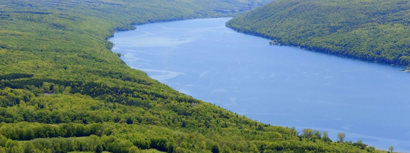
Typically, a network of tributary streams and rivers meet at v-shaped forks that indicate the direction of flow. When water flows into the point of the fork or doubles back after reaching the main branch, it often indicates that the original course has been redirected. Keuka Lake, sometimes called “Crooked Lake,” is the most visible example of this reverse flow. The northern bays of the lake meet at a juncture that points south, but the water flows from south to north. The reversal of the watershed is the after-effect of large deposits of scoured material deposited at the leading edge of the glaciers.

Referred to as a terminal moraine, these deposits effectively dammed the old drainage pattern. The terminal moraine is essentially the apex of one glacial advance and/or indicative of a major halting point during the ebb and flow of the ice. (Note that the most striking example of the deposits at a terminal moraine is Long Island, which was entirely created from glacial deposits.)
The terminal moraine of the last Laurentide glacier in the Finger Lakes region is a broad sweeping arc that encompasses the Finger Lakes watersheds. It effectively fills the lakes with water that would otherwise flow south into the Chesapeake Bay; instead, it flows through the Great Lakes, the St. Lawrence River and eventually into the Atlantic Ocean.
This long route has obvious implications on how the natural system interconnects, but would also influence how the continent would be settled by European colonists. Waterways were the traditional path of least resistance so colonists followed these routes rather than the shorter, more direct overland routes.
Retreating ice, deeper lakes, hanging valleys
Another interesting effect of the terminal moraine occurred as the ice retreated. With the normal drainage pattern blocked and a thick sheet of ice behind, the water coming off the glacier became trapped. The result was that the Finger Lakes were far larger and deeper than today.
Look up to the top of the hillsides encompassing the lakes and imagine the vast glacial lakes that existed then. Streams feed into these immense lakes but when the ice retreated and the lake levels lowered, they would leave behind “hanging valleys.” Staggeringly high waterfalls resulted, of which Taughannock Falls is the most impressive. Over the following millennia, the waterfall and creek have cut a wide gorge (perhaps more accurately described as a canyon) back into the hillside effectively moving the hanging valley westward.

The waterfall and creek were able to alter the landscape so dramatically due to the layers of easily erodible shale and more erosion resistant sandstone (See Natural History, Part 1). The plunging waterfall washed away the many layers of shale so that the sandstone layers were undercut and broke off, moving the crest of the falls westward only to begin the process again.
Massive chunks, sometimes as big as a house are known to cleave off (note this is why you want to stay away from the base of these falls). The rubble is eventually pushed through the gorge into the delta on Cayuga Lake and is presently where Taughannock Falls State Park beach and marina are today.
Pothole lakes, kettle and kame
Another effect of a halting glacier is pothole lakes. Pothole lakes are deep, round lakes that were scoured out by the torrential waterfalls that formed on the leading edge of a glacier. Round and Green lakes in Green Lakes State Park, as well as Glacier Lake at nearby Clark Reservation, are striking examples of this phenomenon. Imagine the waterfall that scoops out the 150-foot high gorge and 195-foot deep lake at Green Lake and you may begin to visualize the immensity of the ice sheets.
To see this process in microcosm visit Buttermilk Falls State Park, where the emerald green potholes underwent and continue to undergo a similar process. Viewed from above, the close proximity of Round and Green Lakes indicate two successional halts in the final retreat of the ice sheets; successive advances would have filled in the potholes with glacial till. Examples of successive potholes from retreating waterfalls can be seen in the ribbon -like creek bed in the Spiral Gorge section of Watkins Glen State Park.
Another indication of the glacier’s passage is the fact that the bottom of two Finger Lakes are actually below sea level — 53 feet below at Cayuga Lake and 173 feet below at Seneca Lake. Erosion proceeds indefinitely upon the landscape until the surface equals the level of the sea/ocean. For a lake to extend below sea level in a region over two hundred miles from the ocean indicates immense land-altering forces.

How such an oddity exists is part of the visible effects of glaciers on the region — U-shaped valleys. Streams and rivers create V-shaped valleys, but throughout central New York are broad U-shaped valleys that lack a stream or river which would account for the broad gulf between the steep-sided hills. People from the region may see this as normal but in other parts of the country (or world), U-shaped valleys are not the norm by any means. Before the glaciers advanced, the region was basically a level plain dissected by streams and rivers that cut the V-shaped valleys. When the glaciers advanced, they scoured out these valleys, broadened their bases, and steepened the sides.
There are many topological features that resulted from retreating glaciers as well. Debris often accumulated in depressions within the ice. Additionally, large chunks of ice often calved off and were covered by and surrounded by similar debris. When the glaciers melted, the accumulated debris would form highly stratified mounds, known as kames, while the buried blocks of ice left behind created deep depressions, known as kettles. The two landforms often coincide and are referred to as kettle and kame topography. Examples of this can be found at Lime Hollow Nature Center and Lindsay-Parsons Biodiversity Preserve.
After effects continue
And the after effects of the glaciers are still not over. It is helpful to remember that the surface crust of the earth is actually “floating” atop a more fluid layer beneath. What happens to a floating object once a massive amount of weight is removed? It rises — and that is precisely what is happening to the previously weighted down portions of North America. The rebounding will take millennia but once complete it is predicted to change the topography so much that Niagara Falls will actual reverse its course.
Clearly, glaciers dramatically altered the landscape and are part of what makes the region so unique. Without them, the landscape would more closely resemble that of the Plains states. It’s important to remember that many of these effects were compounded by the preceding major geological phase — New York as an inland sea — which lasted hundreds of millions of years. The glaciers altered the landscape in less than a tenth of a million years while the next phase has occurred in less than 1% of the glaciers’ time — the effects of human development.
See Natural History, Part 3
Author Tim Starmer provided this natural history series for Go Finger Lakes in addition to writing 50 of the location descriptions. You can read more in his book 5-Star Trails: Finger Lakes and Central New York (Menasha Ridge Press).
Learn More
Conservation
Recreation
Share This